Castlethorpe is a village with a population of about 1,200, set in open countryside seven miles north of Milton Keynes city centre and close to the boundary with Northamptonshire. It lies on the northern edge of the Tove Valley which is designated as a Special Landscape Area. Castlethorpe has been inhabited since the Iron Age and the Castlethorpe dagger, dated 600–400 BC, and the Castlethorpe hoard containing a silver bracelet and coins, from the second century AD, can be seen at the British Museum. Evidence of a Romano-British farm was found during the construction of Maltings Court. Castlethorpe became part of the Saxon and then Norman Manor of Hanslope. The Normans erected the motte and bailey castle and Castle Thorpe, the settlement around the castle, became a distinct village. The castle was destroyed in 1215 during the Barons' Revolt against King John though the mound and ditches remain in good condition in Castle Field. The Parish Church is dedicated to St Simon and St Jude. Originally Saxon, it was extended by the Normans and again throughout the medieval period. The impressive 17th century Monument to Sir Thomas Tyrell, a Lord of the Manor, is installed on the North side of the chancel. The tower collapsed in 1729 and was rebuilt but shorter due to a lack of funds. The Victorians 'restored' the church but a more recent and careful restoration has just been completed. Castlethorpe's agricultural existence was transformed in the mid-19th century with the construction of the London and Birmingham Railway and Castlethorpe station. Castlethorpe 'troughs'where steam engines picked up water at speed were located at the water tower on the cycle track to Haversham where there is now a small recreation area. Many residents worked at the Wolverton Railway Works. In 1904, tragedy struck when a spark from a passing steam train caught on a thatched roof and 13 houses were burnt out, leaving 36 people homeless after the 'Great Fire of Castlethorpe'. The station closed in 1964 as part of the Beeching cuts leaving the busy West Coast Mainline to thunder through. Castlethorpe has 21 Listed Buildings, some dating to the 15th century, and a Scheduled Ancient Monument (Castle Field). It has expanded regularly over recent decades with The Chequers, Sheperton Close, Maltings Field, Fox Covert Lane, Lodge Farm Court, Thrupp Close, Maltings Court, Paddock Close and, most recently, Carrington Grove. In 1974, Castlethorpe became part of the Borough of Milton Keynes, still part of Buckinghamshire, until Milton Keynes became a unitary authority in 1997 and a City in 2022.
Click here to see the Heritage Website: https://www.mkheritage.org.uk/cv/
Latest News
Annual Governance and Accountability Returns
‘The Lounge from the Hatch’ is open!
The Lounge, formerly known as the Pavilion, has re-opened at the Sports Ground. Read More
Proposed New Town based around Haversham
As part of the Government New Towns Proposal, Milton Keynes is one of the designated sites and an area identified around Haversham, running just into Castlethorpe by the Dips and up and around Hanslope Park. It is planned to include up to 21,500 new homes and potentially a new motorway junction at Tathall End. Apart from the ecological - it will cross the Wetlands Arc of the Ouse Valley, and environmental impacts - a new bridge across the Ouse Valley will have to be constructed, and the cost which may well be paid by creating a warehousing facility near the potential new J14a at Tathall End, this amount of housing will take at least 10 years to construct (MK currently builds less than 2,000 houses a year) causing disruption on our main access to Milton Keynes.
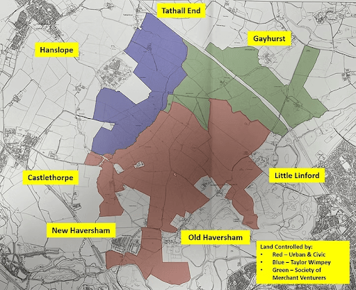
The Government consultation has now ended and thank you to everyone who responded. Our City Councillor, Alison Andrew, proposed a motion at MKCC to ask the government to remove the northern part of the New Town plan around Haversham from its New Town Plans. However, the Liberal-Democrate and Labour Administration defeated the motion. Our MP, Chris Curtis, has held an Open Forum, jointly organised with Alison, so that he could answer questions on the New Town. It was well attended. Chris expressed his doubt about the location and said he needed to be satisfied that five tests had been met: (1) Infrastructure is built before homes (2) that nature is enhanced (3) that genuinely affordable homes are built (4) that green spaces are a part of any designs proposed and (5) that flood mitigation concerns are addressed and, where possible, that development infrastructure actually improves flood defences. At the moment, Chris does not feel these tests are met and he cannot currently give the scheme his support but he will remain engaged with all parties. He also stressed that this is not imminent, not least because of the likely unavailability of government funding for the infrastructure, and that any scheme would have to go through the Planning process which requires compliance with MKCC planning policies.